Signed in as:
filler@godaddy.com

One of the ways HazardCall weather alerts are different is they are based on the highly-specific polygon warnings issued by the National Weather Service.
Introduced in 2007, these polygons (red-boxed area in image), define the direction of dangerous storms. HazardCall ONLY notifies you when you are within the polygon,
Other alerting systems are based on assuming a warning applies to the entire county or counties. These are often so broad, they result in overwarning and confusion.
With HazardCall, there are no false-alarms and no surprises!
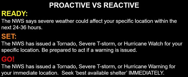
Days before an impactful weather event, the National Weather Service starts a process of communicating with HazardCall to let us know there is an impending threat.
Built into the service a step-by-step process that alerts users as the threat level escalates. This gives them time to prepare and know when to take action
We call this READY-SET-GO- safety, making HazardCall proactive, instead of reactive.
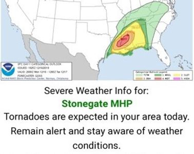
The Storm Prediction Center outlines risk levels for potential storm events. HazardCall sends texts and emails to alert users when there is a significant risk within a day or two. This helps them to start to think about what they would do.
Also, HazardCall messaging includes more detail about the threat so recipients know what to expect and when.
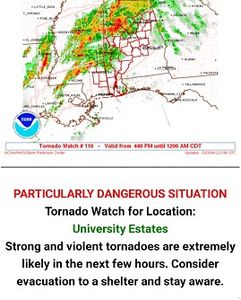
When the National Weather Service issues a 'watch' for a particular weather event, HazardCall puts your residents on notice that they need to be ready to act quickly in the even the NWS ramps to a warning.
Again, notice the messaging, which helps define the often confusing difference between a watch a warning.
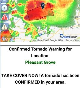
This is the highest level of alert. The weather threat is occurring or will be happening in minutes.
Notice our messaging, which includes safety suggestions, so recipients know what they should do to maintain their safety.
HazardCall informs them so they can act quickly, when seconds count!

The most misunderstood concept in all of the National Weather Service advisory and alerting process is the difference between a WATCH and a WARNING.
Let's make it simple.
A weather-type WATCH: The atmosphere is establishing the conditions where a certain weather event is possible in the upcoming hours or days. A Tornado Watch is issued when, for example, 1-18 hours before tornadic storms could start developing. A Hurricane Watch is issued when hurricane conditions are possible in 36-48 hours. The type of weather event determines how much time is needed for people to make plans to act.
A weather-type WARNING is issued when those conditions are imminent, or have been detected and cause a definite threat to a specific location. A Tornado Warning, for example, is issued when radar or a storm spotter has indicated a developing tornado. These warnings can provide little 'lead-time' at times, all the way up to 45 or 60 minutes. A Hurricane Warning is issued when hurricane conditions are likely within 24-36 hours. In both cases, people need to start to act, often times quickly, to protect themselves.